ENTRE News – The climate crisis that is warming the Earth is said to trigger even crazier behavior than the El Nino and La Nina phenomena. Its form, changes in frequency of appearance and strength.
“There are several impacts of climate change. First, the duration of extreme weather events is more frequent, for example El Nino and La Nina,” said Guswanto.
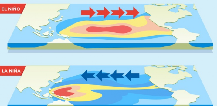
La Nina is a climate anomaly centered in the Pacific Ocean which can increase rainfall in Indonesia. The result is more floods, rain and landslides.
On the other hand, El Nino, an anomaly centered in the same region, triggers a decrease in rainfall and drought in Indonesia.
He reminded that this climate crisis makes the La Nina and El Nino periods, which are basically climate anomalies, faster and stronger in intensity.
“The periods are getting closer together. Second, the intensity or impact is greater, where previously floods usually only lasted 3 days, now they usually take up to a week or even 2 weeks,” he said.
Before global warming became rampant, Guswanto revealed the period of its occurrence was between once every 5 to 7 years. The figure then increases to 3–5 years.
“And now it’s only 2 to 1 year, even,” he continued.
Guswanto exemplified this with the La Nina event that occurred continuously in 2020, 2021, 2022, which is known as the Deep La Nina triple. A year after that, El Nino appeared, which is now still moderate.
El Nino is more frequent but not as strong as before
Climatology researcher at the National Research and Innovation Agency (BRIN) Erma Yulihastin said global warming makes El Nino more frequent than La Nina.
“Global warming makes El Nino more frequent, more frequent than La Nina,” he said, when met at BRIN head office, at the end of January.
However, the effects of the climate crisis have different impacts on El Nino and La Nina. Erma said global warming meant that the intensity and duration of El Nino was not as strong and long as before.
“Often, but the intensity and strength are not always very strong, not Super El Nino above 2 [degrees Celsius] like 1982, 1997, 2015,” he explained.
Under global warming scenarios, El Niño occurs on average about once every 15 years. Now, the distance is getting closer, every 7 to 8 years.
“The frequency is twice as fast for the strong category, above 1.5 [degrees C], whereas previously it was 15 years [once]. However, the intensity will not be above 2 [degrees C], super El Nino,” said Erma.
“The duration of El Nino, although more frequent, is not long, [not] multiyears.”
He exemplified this in El Nino in 2023 which did not trigger forest and land fires (karhutla) as massive as the previous El Nino period. Meanwhile, Erma said global warming made La Nina stronger even though it did not appear as much as El Nino.
“La Nina is the opposite. Global warming makes it not as frequent as El Nino FOR4D but more strong, he said.”
Why does this phenomenon occur? Erma replies that this is part of the Earth’s mechanism for balancing its temperature.
“The CS sea is balancing so that it is not as extreme as [the phenomenon] in 2015,” he said.
Hot records
Guswanto said that 2023 will break many temperature records due to global warming. The previous record was 2016, which was declared the hottest year with an increase in temperature of 1.2 degrees compared to pre-industrial levels.
“In the latest report for 2024, the highest global warming will be around 1.45 degrees in 2023,” he added.
This seemingly trivial increase in temperature actually has a significant impact on the Earth.
“If you look at the parameters of increasing temperature, the impact is quite large, such as there is no longer eternal snow in Puncak Jaya (Papua), now if you look at it it has reduced and only a few remain.”
“In the next 10 years it is possible that snow could also disappear due to global warming which is occurring slowly if mitigation or adaptation to climate change is not carried out,” explained Guswanto.
La Niña Prediction
Erma also predicts that La Nina will appear soon following the fading of El Nino this year.
“According to theory, a strong El Nino will be followed by a strong La Nina. But the opposite does not happen,” he said.
In the Daily Weather Summary for Sunday (31/3), the NINO 3.4 Index was still +1.05, still Moderate, had not dropped to Neutral, and had no effect on increasing rainfall in Indonesia. The US Maritime and Atmospheric Administration (NOAA), in its update as of April 1, revealed that El Nino conditions are currently “observed.”
This can be seen from reports in several areas measuring El Nino. The center is Nino 3.4. Here are the details:
+ Nino 4: 0.8º C
+ Nino 3.4: 1.0º C
+ Nino 3: 0.9º C
+ Nino 1+2: -0.4º C
However, world climate models show that El Nino is starting to realize its ‘break’ plan starting April.
NOAA revealed that a transition from El Nino to neutral ENSO is likely to occur in April-June 2024 (83 percent chance), with the possibility of La Nima increasing in June-August 2024 (62 percent).
The International Research Institute for climate predictions (IRI) also stated “the majority of models suggest El Nino will persist until March-May 2024 and then transition to ENSO-neutral in April-June.”
After a brief period of neutral ENSO conditions, most climate models show a transition to La Niña, which usually triggers lots of rain, around July–September.
